Faites connaître cet article à vos amis:
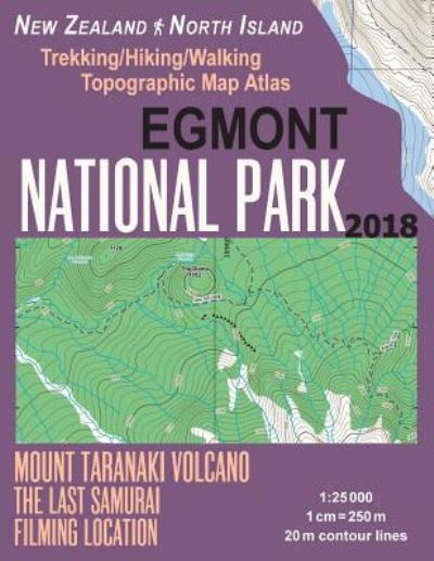
Egmont National Park Trekking / Hiking / Walking Topographic Map Atlas Mount Taranaki Volcano The Last Samurai Filming Location New Zealand North Island 1
Sergio Mazitto
Commandé depuis un entrepôt distant
Nos clients disent :

Egmont National Park Trekking / Hiking / Walking Topographic Map Atlas Mount Taranaki Volcano The Last Samurai Filming Location New Zealand North Island 1
Sergio Mazitto
Updated 2018 edition. Complete map of the Egmont National Park and surrounding area, great walks with breathtaking views and wonderful tramping/hiking trails in the area. Large scale, highly detailed topographic map 1:25.000 & 20 meter contours for hiking and trekking, printed as an atlas book (with overlapping pages).
Around the Mountain Circuit (AMC), Curtis Falls Track, Dawson Falls & Stratford Plateau tracks, Wilkies Pools, Fanthams Peak/Panitahi and Syme Hut, Taranaki Ring Plain, Kaitake Range walking tracks, Kamahi Forest & Kamahi Loop Track, Mt Taranaki from Maketawa Hut Circuit & Summit Tracks, Pouakai Circuit, Veronica Loop Track, Waingongoro tracks, York Road Loop Track etc.
20 meter contour lines, road network, trails & paths, transportation, food, campsites, shelters, guest houses & hotels. Mercator projection with both UTM and WGS84 coordinate grids.
The map scale of 1:25000 (1 cm = 250 meters) provides a wealth of detail while keeping low the weight of the atlas itself. The large page format of 8.5x11in minimizes page count and along with an overlapping map design allows for comfortable navigation.
The details included in the topographic maps of this atlas were specifically selected to be useful for trekkers, hikers and walkers of all interests, and make it easy to plan and enjoy both short excursions and hikes as well as long multi-day adventures along the main marked routes and/or adjacent trails and paths, which are also shown on the maps.
With this ultralight atlas you will always have a detailed, reliable, information-rich, battery-independent, shatter-proof map for your adventure.
| Médias | Livres Paperback Book (Livre avec couverture souple et dos collé) |
| Validé | 5 janvier 2018 |
| ISBN13 | 9781983589416 |
| Éditeurs | Createspace Independent Publishing Platf |
| Pages | 40 |
| Dimensions | 216 × 280 × 3 mm · 154 g |
| Langue et grammaire | English |