
Faites connaître cet article à vos amis:
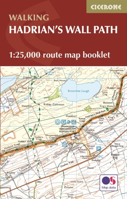
Hadrian's Wall Path Map Booklet: 1:25,000 OS Route Mapping 2 Revised edition
Mark Richards
Prix
Íkr 2.161,70
Commandé depuis un entrepôt distant
Livraison prévue 24 - 30 avr.
Nos clients disent :


Ajouter à votre liste de souhaits iMusic
Hadrian's Wall Path Map Booklet: 1:25,000 OS Route Mapping 2 Revised edition
Mark Richards
Map of the 84 mile (135km) Hadrian's Wall Path National Trail, from Bowness-on-Solway to Wallsend, Newcastle. The full route line is shown on 1:25,000 OS maps and can be used to walk the trail in either direction.
56 pages
| Médias | Livres Paperback Book (Livre avec couverture souple et dos collé) |
| Validé | 4 août 2023 |
| ISBN13 | 9781786311511 |
| Éditeurs | Cicerone Press |
| Pages | 56 |
| Dimensions | 166 × 106 × 5 mm · 62 g |
| Langue et grammaire | English |
Afficher tout
Plus par Mark Richards
![Cover for Mark Richards · Walking the Lake District Fells - Patterdale: Helvellyn, Fairfield and the East (Paperback Book) [2 Revised edition] (2020)](https://imusic.b-cdn.net/images/item/original/347/9781786310347.jpg?mark-richards-2020-walking-the-lake-district-fells-patterdale-helvellyn-fairfield-and-the-east-paperback-book&class=scaled&v=1592856160)
![Cover for Mark Richards · Walking the Lake District Fells - Mardale and the Far East: High Street and Kentmere (Paperback Book) [2 Revised edition] (2020)](https://imusic.b-cdn.net/images/item/original/354/9781786310354.jpg?mark-richards-2020-walking-the-lake-district-fells-mardale-and-the-far-east-high-street-and-kentmere-paperback-book&class=scaled&v=1592150215)


![Cover for Mark Richards · Fundamentals of Software Architecture: A Modern Engineering Approach (Paperback Book) [2 Revised edition] (2025)](https://imusic.b-cdn.net/images/item/original/511/9781098175511.jpg?mark-richards-2025-fundamentals-of-software-architecture-a-modern-engineering-approach-paperback-book&class=scaled&v=1728347167)
![Cover for Mark Richards · A Practical Approach to Conveyancing (Paperback Book) [24 Revised edition] (2024)](https://imusic.b-cdn.net/images/item/original/365/9780198873365.jpg?mark-richards-2024-a-practical-approach-to-conveyancing-paperback-book&class=scaled&v=1711151165)
![Cover for Mark Richards · Walking the Lake District Fells - Keswick: Skiddaw, Blencathra and the North (Paperback Book) [2 Revised edition] (2024)](https://imusic.b-cdn.net/images/item/original/378/9781786310378.jpg?mark-richards-2024-walking-the-lake-district-fells-keswick-skiddaw-blencathra-and-the-north-paperback-book&class=scaled&v=1603165268)
![Cover for Mark Richards · Walking the Lake District Fells - Wasdale: The Scafells, Great Gable, Pillar (Paperback Book) [2 Revised edition] (2024)](https://imusic.b-cdn.net/images/item/original/316/9781786310316.jpg?mark-richards-2024-walking-the-lake-district-fells-wasdale-the-scafells-great-gable-pillar-paperback-book&class=scaled&v=1570392025)
![Cover for Mark Richards · Walking the Lake District Fells - Langdale: The Langdale Pikes and Bowfell (Paperback Book) [2 Revised edition] (2023)](https://imusic.b-cdn.net/images/item/original/323/9781786310323.jpg?mark-richards-2023-walking-the-lake-district-fells-langdale-the-langdale-pikes-and-bowfell-paperback-book&class=scaled&v=1570392026)
![Cover for Mark Richards · Hadrian's Wall Path: National Trail: Described west-east and east-west (Paperback Book) [4 Revised edition] (2023)](https://imusic.b-cdn.net/images/item/original/504/9781786311504.jpg?mark-richards-2023-hadrian-s-wall-path-national-trail-described-west-east-and-east-west-paperback-book&class=scaled&v=1665011427)


![Cover for Mark Richards · Walking the Lake District Fells - Coniston: The Old Man of Coniston, Swirl How, Wetherlam, Duddon valley and Eskdale (Paperback Book) [2 Revised edition] (2021)](https://imusic.b-cdn.net/images/item/original/392/9781786310392.jpg?mark-richards-2021-walking-the-lake-district-fells-coniston-the-old-man-of-coniston-swirl-how-wetherlam-duddon-valley-and-eskdale-paperback-book&class=scaled&v=1603707952)
![Cover for Mark Richards · Walking the Lake District Fells - Buttermere: High Stile, Grasmoor, Grisedale Pike and Haystacks (Paperback Book) [2 Revised edition] (2020)](https://imusic.b-cdn.net/images/item/original/361/9781786310361.jpg?mark-richards-2020-walking-the-lake-district-fells-buttermere-high-stile-grasmoor-grisedale-pike-and-haystacks-paperback-book&class=scaled&v=1603188511)
D'autres ont aussi acheté


Voir tous les Mark Richards ( par ex. Paperback Book , Hardcover Book , Pamphlet , Book et CD )