Faites connaître cet article à vos amis:
Turkey Fethiye-Antalya Topographic Map Atlas with Index 1
Sergio Mazitto
Commandé depuis un entrepôt distant
Nos clients disent :

Turkey Fethiye-Antalya Topographic Map Atlas with Index 1
Sergio Mazitto
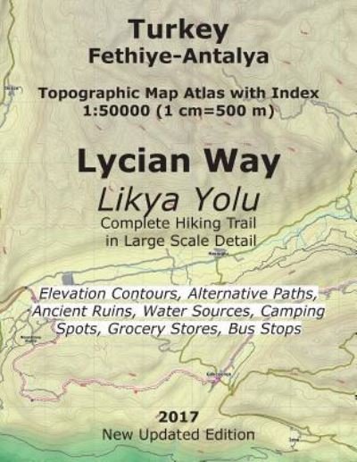
This detailed, full color Topographic Atlas represents the latest extended version of the famous Lycian Way hiking trail in southwest Turkey. The approx. 540-km long trail runs along the Mediterranean coast of Turkey, connecting the town of Fethiye in the west with the village of Geyikbay?r?, close to Antalya, in the east. The route as shown in the Atlas includes the trails from Fethiye through the ghost Greek village of Kayaköy in the west and the latest extension from Hisarçand?r to Geyikbay?r? in the east. The Index makes it easy to find all cities, towns and villages along the route and nearby, as well as prominent tourist attractions, historic and archeological sites, ruins, temples etc. The details included in the topographic maps of this Atlas were specifically selected to be useful for trekkers, hikers and walkers of all interests, and make it easy to plan and enjoy both short excursions and hikes as well as long multi-day adventures along the main marked route and/or adjacent trails and paths, which are also shown on the maps. Among the points of interest selected for the maps are historic sites, caves, lighthouses, marinas and sea ports, sea and shore wrecks, castles, forts and ancient city sites, rock climbing areas, etc. A lot of attention has also been given to navigation landmarks, terrain relief (with elevation contours drawn every 20m and all important mountains marked, along with the routes to ascend to the top when known), water sources (natural springs, cisterns, wells, water taps and drinking fountains), road network and public transportation hubs, bus stations and bus stops, grocery stores and accommodation options (hotels, guest houses and commercial campsites, as well as good wild camping spots), up to such minute detail as beach showers where that information was available. The map scale of 1:50000 (1 cm = 500 meters) provides a wealth of detail while keeping low the weight of the atlas itself. The large page format of 8.5x11in minimizes page count and along with the overlapping map design allows for comfortable navigation. Bend this ultralight atlas in half, stuff it in the side pocket of your backpack, and you'll always have a detailed, reliable, information-rich, battery-independent, shatter-proof map for your adventure.
| Médias | Livres Paperback Book (Livre avec couverture souple et dos collé) |
| Validé | 7 mai 2017 |
| ISBN13 | 9781546512073 |
| Éditeurs | Createspace Independent Publishing Platf |
| Pages | 38 |
| Dimensions | 216 × 280 × 3 mm · 145 g |
| Langue et grammaire | English |